HistorySmoky Hill Trail & Butterfield Overland Despatch (B.O.D.)The Smoky Hill Trail started being used in 1858 when gold was discovered at Cherry Creek by Denver. There are many stories about the trials and tribulations associated with traveling the trail and different groups efforts to improve traveling conditions. Monument Station and Monument RocksMonument Rocks became one of the famous landmarks along this route and a B.O.D. marker exists just south of there. The “Fort” was located west of Monument Rocks, but nothing remains in this area. It is on private land, so please do not trespass into the area. “It was one of the most famous stations along the trail, not only for the unusual rock formations in the vicinity but for the Indian troubles that forced the army to station a detachment of soldiers here and designate it a fort. A mile to the northeast of the station were the Monuments, castle-like rocks that rose abruptly out of the level prairie. These rocks are sometimes called the Pyramids because of their proximity to Chief Smoky, the Kansas Sphinx. This solitary rock stands to the north of the main cluster of towering monuments and does bear a remarkable resemblance to a human head. The monuments are just north of the Smoky Hill River… The station was built very much like the others. The stable was a long dugout gouged into the north bank of the river, where it was well protected from the weather and within easy reach of the river itself”
Time Table1854, May 30: Kansas became a territory 1858: Smoky Hill Trail regularly used since gold had recently been discovered at Cherry Creek, near Denver in Kansas Territory. Denver was founded and then named after Kansas Territorial Governor James W. Denver. 1859, Spring: “newspapers on both ends of the route began lamenting about the hardships of the trail. Kansas City papers reported the stories coming from the trail and concluded: ‘How often will it be necessary to tell the public that there is no road up the Smoky Hill.’” “Several men coming up the trail had gotten lost because there were no markers. Any other route is better than the Smoky Hill road,” stated the first issue of the Cherry Creek Pioneer newspaper. “The Rocky Mountain News in Denver reported that men were arriving every day from the states by way of the Smoky Hill Trail and most of them were half-starved. One story reported that three men had starved to death on the trail. Still another story told by an emigrant, although it was unverified, told of seventeen men in one party who had starved to death. One emigrant reported that the remains of a hundred men could be found along the road. “An editorial in the News condemned the men and newspapers in the East that had encouraged people to start out on the Smoky Hill Trail with so few provisions, expecting to find a good road and good camps with plenty of wood and water. Instead, they had found no road at all, very little wood and, in many places, no water.” 1859: The Smoky Hill Trail became known as the Starvation Trail when the Blue brothers were forced to cannibalism during a long and arduous trek to Denver. Alexander, Daniel and Charles Blue along with their traveling companion Soley, not only made bad navigation choices on the unmarked trail, but received erroneous information about the availability of food and water. They also encountered early spring blizzards which slowed their travel, plus assumed distances were closer than the actual miles. Although well supplied with food and a packhorse when leaving Leavenworth, Kansas, the brothers ran out of food somewhere in western Kansas and their packhorse had previously been stolen by Indians during the night. According to newspaper accounts, told by lone survivor Daniel Blue, they made a pact that whoever died should be eaten so the others would survive. Soley died first and the brothers consumed him even though this was a despicable act to them. Alexander Blue was next to die and the brothers eventually followed the pact to survive by eating their brothers’ body. Daniel and Charles had been trekking onward with the false hope that they were close to Denver, with Pike’s Peak in sight glimmering in the distance. Charles, the youngest of the three, could not make it any longer and also expired from lack of food and deplorable conditions. Daniel finally made the decision to use his brothers’ body for food sustenance to finish his long trip. After all these hardships, Daniel finally could not go on and laid down to die. Arapahoe Indians found his almost lifeless body and nursed him back to traveling health. On May 11th, Daniel Blue arrived in Denver telling his story which sickened even the hardiest of miners, townspeople, and pioneers. News spread quickly of the brothers’ ordeal and travel ceased on the Smoky Hill for a time. The route needed to be surveyed and marked to show for the best route for water and where the trail actually was located. 1858-1860: Gold seekers walked, drove wagons, pushed two wheeled carts and lugged wheelbarrows across the plains to reach the gold fields. It was the shortest trail by one hundred miles to the gold regions. 1861: Henry Green of Leavenworth, KS was hired to build a road across the plains and to establish a well-marked route. They used big mounds of dirt, one about every mile ‘so that there could be no trouble in finding it hereafter.’ “One man returning in late October praised the road but issued a warning. He reported that herds of buffalo were destroying the mounds of dirt piled up by the road builders to mark the road and said if something wasn’t done a new survey might have to be made.” 1860-1865: Frequent Indian troubles and the lack of protection from the government led to the trail’s unpopularity for a while. Indian attacks were common while the white man transversed or trespassed through prime Indian hunting grounds. .1865: David A. Butterfield decides to have the Smoky Hill route resurveyed as the shortest way to Denver since there was a dramatic increase in freight shipments coming up the Missouri river to be transported to Denver. 1865: June 13: B.O.D. route surveyed 1865: B.O.D officials said that it was essential to have troops protecting the route. 1865, June 24: A small wagon train carrying 150,000 pounds of freight left Atchison on the newly established Butterfield Overland Despatch route. Cost was 22 ½ cents per pound on these first freight trains. 1865, September 11: The first stagecoach to ever use the new B.O.D. or Smoky Hill Trail leaves Atchison and arrives in Denver on September 23, 1865. The fare from the Missouri river to Denver was $175.00 with meals costing an extra $1.00 in the west. 1865: Theodore H. Davis wrote for Harper’s Magazine and came out west to make sketches of life on the prairies. He wrote of Monument Rocks: .“’The Monuments” were reached this evening; near them is a camp of more than two hundred soldiers. A fort is to be built, also a station. These Monument rocks are considered the most remarkable on the plains. At a distance it is difficult to realize that they are not the handiwork of man, so perfectly do they resemble piles of masonry. The wind that night was terrific. Two tents were blown away, and a wagon that was not brought into the corral overturned. The mules stood with their backs to the blast, that caused their hair to stand out like fur. We left Monument early on the morning of the 25th, to continue our journey. An ambulance, containing a surgeon and four men, accompanied us as well as the escort of five cavalrymen. The next station was twenty-two miles distant.” Published in Harper’s Monthly on July, 1867 1865, October and November: Troops arrived at Monument Station--Company A of the 1st U. S. Volunteer Infantry and the 13th Missouri Volunteer Cavalry. Confederate Prisoners of War made up the 1st and were called the “Galvanized Yankees”. These soldiers, upon being released from prison, were sent out to the west, where they could not take up arms against the Union. 1865, October 1: First attack by Indians on a B.O.D stagecoach. Attacks steadily increased after this. Several stations were burned and a coach-driver killed. The cavalry did not deter the Indians who used this area as their prime buffalo hunting grounds... 1865, October 26: Fort Wallace was established shortly after this time period. Troops there included the 2nd U.S. Cavalry; 6th U.S. Volunteer Infantry, another Galvanized Yankee unit; and the 3rd, 5th, 19th, and 27th U.S. Infantries. 1866: Monument Station (formerly Antelope Station) was proposed as an actual Fort, but remained as a station throughout its brief years of activity. 1866: “The little fort at Monument Station was having trouble surviving. According to the Fort Fletcher records an officer was sent to Monument Station on January 12. On January 14, Lieutenant Bell of the Thirteenth Missouri Cavalry was sent to Fort Fletcher with two wagons of supplies for Pond Creek Station and Monument Station. There is no record that the supplies ever reached Monument Station. It is a good guess that they didn’t, for the post apparently was abandoned. The record shows that Companies A, E, and I of the First Volunteer Infantry were sent to Monument Station on March 1 to “re-establish” the post.
1866, June: Bayard Taylor, a correspondent for the New York Tribune gave this report during a lull between fighting with the Indians. “Half asleep and half awake, now lulled into slumber by the slowness of our progress, now bumped into angry wakefulness in crossing some deep gully, we dragged through the night, and in the morning found ourselves at Downer’s, 44 miles farther. Our breakfast here was another ‘square meal’ pork fat and half-baked biscuits. At all the stations the people complained of lack of supplies, some were destitute of all but beans. Monument Station is so called from a collection of quadrangular chalk towers, which rise directly from the plain. At first sight, they resemble a deserted city, with huge bastioned walls; but on a nearer approach they separated into detached masses, some of which resemble colossal sitting statues. The station house is built of large blocks, cut out with a hatchet and cemented with raw clay.” 1867 & 1868: The Buffalo soldiers of the 10th Cavalry were stationed at Fort Wallace in September of 1868 and were also active out of Fort Hays in 1867. These soldiers were stationed all across the plains during the Smoky Hill Trail days and Indian uprisings. 1868, June 24: “On June 24, the soldiers at the fort at Monument Station were ordered to the new end-of-the track town of Monument to guard supplies and protect the railroad workers. Since both stages and freighters were meeting the train at Monument there seemed little need of a fort down on the river. The town of Monument was thirty-five miles northwest of the Monument Station of the B.O.D.” 1868 June 24: The original Monument Station was ordered abandoned by the U.S. Government and the troops marched to Antelope Springs which was thereafter known as Monument Station. 1868, December: Wells Fargo – the daily coach fare on the Smoky Hill Route from Leavenworth to Denver was $58.78. 1870, August 21: Last stage coach 1882: Fort Wallace Abandoned 1888: Pyramid Town and Post Office was established southeast of the Pyramids. The Post Office was discontinued in 1891. 1943: Smoky Hill AAGR (Army Airfield Gunnery Range) Between 1943 and 1945 a large portion of our area was used for air-to-air gunnery range activity. The Department of Defense temporarily acquired 340 square miles (218,384 acres) of land east of US 83 highway in Gove, Logan, Scott, and Lane counties, including Monument Rocks. The deal mandated relocation of all inhabitants in the area. After the land was returned to its owners, many chose not to move back. The mission training crews for the B-29 Superfortress heavy bombers came from Schilling Air Force Base in Salina, Kansas (Smoky Hill AAF-Army Airfield, 200 miles east) and McCook, Nebraska AAF (100 miles north). Walker AAF (100 miles east) may have also used the range. There is evidence to suggest B-17s utilized the area too. Lead planes towed a sleeve target while flexible guns fired at them. The “armament for the B-29 bomber included eight .50-caliber machine guns mounted in four remote-controlled turrets, two .50-caliber machine guns and a 20mm cannon mounted in a tail turret.” (National Air and Space Museum. McCaffery, 2008) The 20mm round was being tested for Britain. Unauthorized air-to-surface practice probably did occur at Monument Rocks and other various formations. There are many local accounts of people picking up rounds of unused ammunition inside and outside the official use area and spent rounds are still found infrequently. The DoD declared the land surplus in May of 1946 and the majority of the property rights were terminated and reverted back to the landowners in November 1946. 1947, February 27: There was a dance and social gathering at the Pyramid school house Saturday evening. This school was located north of Monument Rocks and burned down in 1981.
Additional Stories from Scott County History Book:Loran Wright’s parents homesteaded in SW Gove County. His father built a two-room rock house using rock from the remains of an Indian Fort which was located near the Smoky Hill River. The government used his farm land as a gunnery range, causing the family to vacate their land. A Spring rain caused many hardships for a young Henry Sears who related this story for his family’s entry in the Scott County history book. “It was a young flood, and when we got up the next morning the ground was a big mud hole and the river was up. We were afraid to cross at the regular crossing, when we got to our home place south of the Pyramids. When we got home we were as wet as if we had just crawled out of the old Smoky River. We heard afterward that two men and two women and their team and wagon were washed away while trying to cross somewhere north of old Elkader, I think it was, although I don’t remember the place.” Resource Material Note: All entries in the timeline, unless otherwise specified, were taken from Trails of the Smoky Hill by Wayne C. Lee and Howard C. Raynesford, 1980, Caxton Press. This is the definitive book describing events and the history of the Smoky Hill Trail. Howard Raynesford walked every mile of it, plus drew detailed maps of stations and where the trail actually went through western Kansas. ©2015 Keystone Gallery / Photos © Barbara Shelton unless otherwise noted |
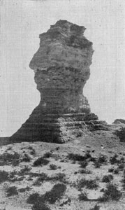 Old Chief Smoky (or the Kansas Sphinx) fell down in 1986. Monument Rocks was also called the Kansas Pyramids, and both names are still used to this day.
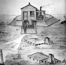
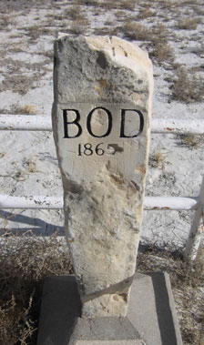 1963: Howard Raynesford started placing the first B.O.D. markers along the Smoky Hill Trail. These markers engraved with B.O.D. 1865 were erected on the side of every graded road that crossed the trail. One marker is placed by the cattle guard just south of Monument Rocks where the trail ran through by the Smoky Hill River.